Scientists Finally Reached the Hidden Interior of Noah’s Ark Site — What They Found
Scientists Finally Reached the Hidden Interior of Noah’s Ark Site — What They Found
DOĞUBAYAZIT, Turkey — In the high, wind-scoured steppes of eastern Turkey, where the borders of three nations blur under the shadow of Mount Ararat, the earth occasionally mimics the hand of man. Along a rugged ridge roughly 18 miles south of the biblical peak sits a massive, boat-shaped depression known as the Durupınar Formation. To a casual traveler, it is a striking anomaly—a flawless, double-ended hull of packed earth and rock stretching 538 feet through the limestone terrain. To geologists, it is a classic syncline, a natural product of tectonic uplift and shifting mudslides. But to a persistent subculture of explorers, archaeologists, and believers, it is the holy grail of biblical archaeology: the final resting place of Noah’s Ark.
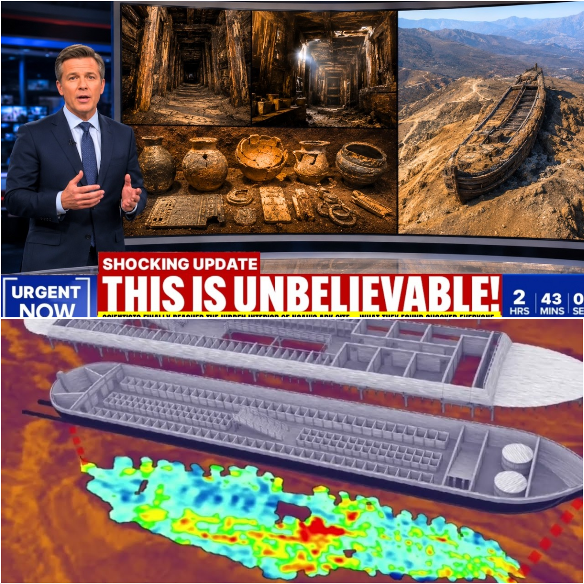
Decades after it was first spotted on an aerial surveillance map, the Durupınar site has once again surged into global headlines, re-igniting an old and deeply American debate over faith, literalism, and the boundaries of empirical science. The latest frenzy has been fueled not by a physical piece of timber pulled from the soil, but by bytes of data. A joint team of Turkish and American researchers, deploying advanced subsurface radar imaging and soil-analysis techniques, claim to have detected organized, “compartment-like” anomalies beneath the surface, suggesting a hidden, interior structure.
The announcement has triggered a familiar, highly predictable cycle of sensationalism and skepticism. For generations of Americans raised on Sunday school stories and late-night documentaries, the possibility of finding the Ark taps into a profound cultural desire to anchor ancient narratives to concrete reality. Yet, as mainstream scientists point out, the language of advanced imaging can easily be used to dress up old illusions in a lab coat. The enduring mystery of Durupınar is not necessarily what lies beneath the dirt, but why the American imagination refuses to let it go.
The Landscape of the Literal
To understand why a geological anomaly in a remote Turkish province can command prime-estate headlines in American media, one must understand the unique geography of American religious history. While European biblical scholarship spent the nineteenth and twentieth centuries moving toward historical-critical models—viewing stories like the Genesis flood as theological allegories rooted in older Mesopotamian myths—a massive swath of the American public moved in the opposite direction.
For millions of American evangelicals, the historical accuracy of scripture is the linchpin of faith. If the flood did not happen exactly as described in Genesis, the theological framework built upon it begins to fracture. Consequently, “Ark-hunting” became a distinctly American pastime, combining the rugged spirit of frontier exploration with the zeal of a religious crusade.
Over the decades, expeditions financed by American donors have combed the ice caps of Mount Ararat, dodging Kurdish rebels, Turkish military checkpoints, and treacherous glaciers. But while Ararat itself is a unforgiving vertical wall of volcanic rock, the Durupınar Formation offered something far more tangible: a shape.
First captured in 1959 by Turkish air force captain İlhan Durupınar during a NATO geodetic survey, the site instantly captivated the West. Life magazine published an exposé in 1960, bringing the image of the “Boat of Ararat” into millions of American living rooms. Since then, the site has been the subject of countless books, independent documentaries, and amateur excavations. Every few years, a new generation of explorers arrives with new tools, claiming that the definitive proof is just inches beneath the topsoil.
The Geometry of a Myth
The persistent allure of the Durupınar Formation lies in its dimensions. The 538-foot length of the formation corresponds remarkably close to the 300 cubits prescribed in the biblical instructions for building the Ark, assuming a standard ancient Egyptian or Babylonian measurement.
For decades, the debate was fought entirely on the surface. Proponents pointed to the pointed prow, the rounded stern, and the symmetrical “ribs” running down the flanks of the formation as evidence of petrified timber. Geologists, however, countered that the site is merely an erosional feature formed by a flowing mud-and-debris field around a stationary block of underlying limestone. The “ribs,” they argued, are nothing more than natural weathering patterns in the clay layers.
The latest round of controversy, covered extensively by outlets like Fox News and The Jerusalem Post, represents a tactical shift. Realizing that surface arguments had reached a stalemate, researchers turned their focus inward, using ground-penetrating radar (GPR) and electrical resistivity tomography.
According to the research teams, these subsurface scans revealed highly organized anomalies beneath the limestone crust—linear patterns, tunnels, and deep cavities that do not align with the random chaos of local geology. To the investigators, these readings suggest the presence of internal decks and partitions, the literal interior of a preserved vessel.
“The data shows parallel lines and right angles beneath the surface,” says Dr. Jonathan Reynolds, an American independent researcher who has spent years tracking the site’s history. “Nature rarely works in straight lines or perfect right angles over hundreds of feet. When you combine the external geometry with the internal scanning, it becomes increasingly difficult to dismiss this as a mere trick of nature.”
Data vs. Interpretation
However, within the broader scientific community, the announcement was met with a collective sigh. To an experienced geophysicist, the claim that a radar scan has found “rooms” inside a mountain is a textbook example of pareidolia—the human tendency to perceive meaningful patterns in random information.
Ground-penetrating radar is a highly sophisticated tool, but it does not produce a photograph of what lies beneath the earth. Instead, it measures changes in density, moisture content, and material composition, translating those differences into waves of data. Interpreting those waves requires a massive degree of contextual knowledge, and the line between an objective finding and a hopeful inference is notoriously thin.
“Geology is incredibly adept at creating structured anomalies,” explains Dr. Sarah Vance, a prominent American geologist specializing in Near Eastern landforms. “When you have layered sedimentary rocks that have been subjected to tectonic compression, folding, and subsequent erosion, you will get parallel reflections and vertical fractures that look precisely like walls and corridors on a radar screen. Without rigorous, peer-reviewed excavation, a scan is just a digital Rorschach test.”
Furthermore, critics note that the researchers have yet to publish their raw data in reputable, independent scientific journals. Instead, the findings are frequently rolled out via press releases, religious conferences, and self-produced digital media. This methodology allows the narrative to capture public imagination before it can be subjected to the clinical, often devastating scrutiny of peer review.
The Alchemy of the Soil
In an attempt to fortify the radar findings, recent expeditions have also focused on the chemistry of the site. Investigators reported that core soil samples taken from within the formation reveal variations in mineral composition and higher levels of organic content compared to the surrounding hillsides. Some reports have even pointed to distinct vegetation patterns, noting that certain grasses grow differently along the perimeter of the “hull.”
In the language of viral internet content, these details are treated as overlapping lines of evidence—a cross-disciplinary confirmation of a hidden structure. The logic is intuitive: if the shape, the scans, and the soil all exhibit anomalies, they must be pointing to the same extraordinary conclusion.
But in the world of academic archaeology, multiple uncertain observations do not automatically combine to create a certainty. Soil chemistry is influenced by thousands of localized factors, including micro-climates, the way rainwater pools within the depression, and the specific mineral makeup of the sliding mud. A structural variation beneath the surface can alter how water moves through the ground, which in turn changes nutrient distribution and influences plant growth. This is a well-known geological process, completely independent of whether a Bronze Age vessel is buried beneath the turf.
“The public is often shown a finished interpretation rather than the messy reality of the data,” says Dr. Vance. “They hear ‘organic material’ and they think of animal pens or ancient wood. They don’t think of centuries of decaying plant matter, animal grazing, or localized microbial activity that naturally concentrates in a geographic depression.”
The Cinematic Pull of the Search
Why, then, does the Durupınar Formation remain such a potent fixture in the cultural ether? The answer has less to do with the rigors of archaeology and more to do with the mechanics of modern storytelling.
The narrative of the search for Noah’s Ark is fundamentally cinematic. It possesses all the elements of a classic American adventure film: a remote and dangerous landscape, a relic of cosmic significance, a band of dedicated believers fighting against the dismissive scoffing of an elite academic establishment, and the constant promise that a single breakthrough will change the world forever.
When a story is structured this way, the actual evidence becomes secondary to the emotional journey. Each new scan or soil sample is cast as a plot point in an unfolding mystery, keeping audiences clicking, sharing, and debating. On platforms like YouTube and TikTok, clips of the Durupınar site generate millions of views, fueled by algorithms that reward high-stakes controversy over cautious nuance.
For many viewers, the idea that modern technology is finally peeling back the layers of a millennia-old mystery offers a profound sense of reassurance. It suggests that despite the complexity and disillusionment of the modern world, the grand stories of our past are still there, waiting to be found in the dirt.
The Unresolved Mountain
Ultimately, the Durupınar Formation occupies a permanent borderland between science and sentiment. It is an uncomfortable space where a promising lead and an unproven speculation look identical to the untrained eye. Because the site sits in a sensitive geopolitical region and carries immense religious weight, a full-scale, definitive scientific excavation remains unlikely for the foreseeable future.
And perhaps that is exactly why the story survives. If the site were to be comprehensively excavated and proven to be nothing but stone, the mystery would die, and with it, the enchanting possibility that the past is entirely knowable. If it were somehow proven to be an artifact, the search would end.
Instead, the mountain keeps its secrets, remaining exactly where it has always been, outlasting the headlines, the documentaries, and the theories of each passing generation. For the believers, the shape in the stone will always be a vessel of hope. For the skeptics, it will always be a monument to human imagination. Until the earth itself opens up to give a final answer, the Durupınar Formation will remain suspended between possibility and proof—a digital ghost haunting the intersection of faith and science.
https://youtu.be/wB-NJxNmWNA?si=7PPqGgWrnez6fyFi